
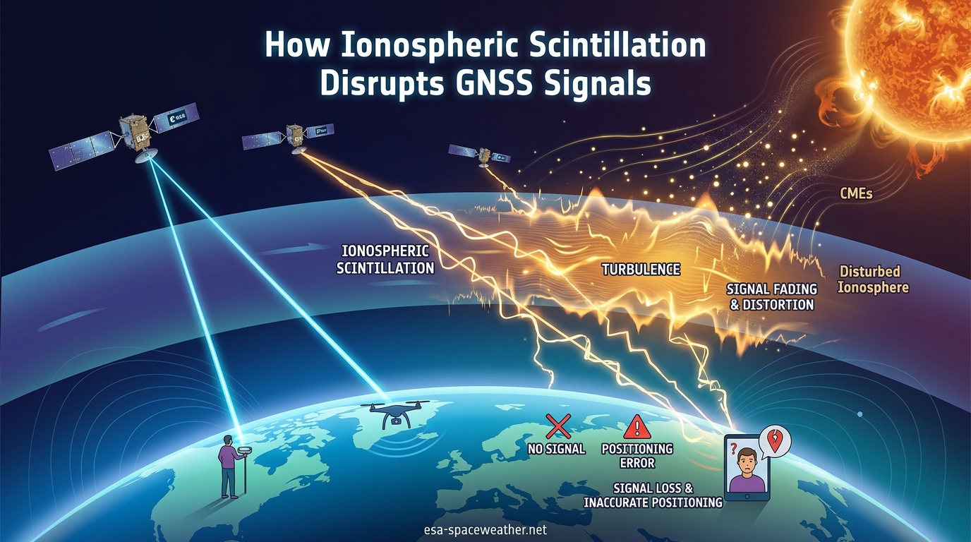
In this guide, we break down exactly how ionospheric scintillation disrupts GNSS signals, why it happens, where it strikes hardest, and what you can do about it. Whether you are a GNSS professional dealing with position jumps during solar storms or an enthusiast trying to understand why your receiver behaves erratically, this article will give you clear, practical answers.
Ionospheric scintillation is the rapid modification of GNSS radio waves caused by small-scale structures in Earth’s ionosphere. When satellite signals pass through regions of rapidly fluctuating electron density, the signals undergo rapid amplitude and phase fluctuations that degrade signal quality, cause tracking errors, and can produce complete loss of receiver lock. Understanding this phenomenon is essential for anyone relying on high-accuracy positioning during periods of elevated solar activity.
Table of Contents
Quick Answer: How Ionospheric Scintillation Disrupts GNSS Signals
Ionospheric scintillation disrupts GNSS signals by scrambling the radio waves as they travel through irregular patches of ionized gas in the upper atmosphere. The disruption happens through two primary mechanisms: amplitude scintillation, which causes rapid drops in signal power, and phase scintillation, which causes rapid fluctuations in the signal’s phase. Together, these effects confuse GNSS receiver tracking loops, reduce positioning accuracy, and in severe cases, make it impossible for the receiver to calculate a position at all.
Here is a step-by-step breakdown of the disruption chain:
- Electron density irregularities form in the ionosphere due to solar activity, creating small-scale structures ranging from tens of meters to tens of kilometers.
- GNSS signals encounter these irregularities as they travel from satellites at 20,000+ km altitude down to receivers on Earth.
- Refraction and diffraction occur as radio waves pass through varying electron densities, splitting and bending the signals.
- Amplitude and phase fluctuations result from interference between the refracted and diffracted waves reaching the receiver.
- Signal fades and phase scintillation hit the receiver, causing the tracking loops in the receiver to struggle or fail.
- Loss of lock occurs when the signal degradation exceeds the receiver’s ability to track, producing position jumps, increased error, or complete positioning failure.
This chain of events can happen in seconds. A receiver that was working perfectly moments earlier can suddenly lose satellite after satellite as a scintillation event sweeps through.
The Ionosphere: Earth’s Radio Signal Filter
The ionosphere is a layer of Earth’s upper atmosphere, sitting roughly between 60 and 1,000 kilometers above the surface. It contains high concentrations of ions and free electrons, produced when extreme ultraviolet and X-ray radiation from the Sun strips electrons from atmospheric gas molecules. This ionized layer reacts to the Sun’s radiation in real time, expanding during the day, contracting at night, and intensifying dramatically during solar flares and geomagnetic storms.
For GNSS signals, the ionosphere acts as both a filter and a delay mechanism. All GNSS satellites orbit well above the ionosphere. GPS satellites operate at approximately 20,200 km, Galileo at 23,222 km, GLONASS at 19,100 km, and BeiDou satellites range from 21,500 km (MEO) up to 35,786 km (GEO). Every signal from every constellation must pass through the ionosphere before reaching a receiver on the ground.
Under normal conditions, the ionosphere imposes a predictable group delay on GNSS signals proportional to the Total Electron Content (TEC) along the signal path. Receivers can model and correct for this delay using dual-frequency observations or broadcast ionospheric models. The problem arises when the ionosphere becomes irregular, because small-scale structures in electron density create unpredictable, rapid signal fluctuations that no standard model can correct.
Total Electron Content, measured in TEC Units where 1 TECU equals 10^16 electrons per square meter, is the key parameter for understanding ionospheric conditions. Typical vertical TEC values range from 10 TECU at mid-latitudes at night to over 150 TECU in the equatorial region during daytime at solar maximum. The higher the TEC and the more irregular its distribution, the greater the potential for scintillation.
What Causes Ionospheric Scintillation?
Ionospheric scintillation is caused by small-scale structures, or irregularities, in the electron density of the ionosphere. These irregularities form when the smooth, uniform distribution of ionized gas becomes turbulent, creating pockets of higher and lower electron concentration. Radio waves passing through this turbulent medium are refracted and diffracted, producing the interference patterns that manifest as scintillation at the receiver.
The primary drivers behind these electron density irregularities include:
- Solar flares and solar storms: Sudden bursts of energy and particles from the Sun dramatically increase ionization levels and can trigger geomagnetic disturbances that destabilize the ionosphere.
- Sunspot activity and solar cycle: The Sun goes through approximately 11-year cycles of activity. We are currently in Solar Cycle 25, which reaches its maximum in 2026, meaning elevated scintillation risk.
- Equatorial plasma bubbles: After sunset in the equatorial region, plasma instabilities create rising bubbles of depleted electron density that generate intense scintillation conditions.
- Geomagnetic storms: Disturbances in Earth’s magnetic field, often driven by coronal mass ejections, inject energy into the high-latitude ionosphere and create irregularities that produce phase scintillation.
- Atmospheric gravity waves and lower atmosphere coupling: Weather patterns and atmospheric waves from the lower atmosphere can propagate upward and seed ionospheric irregularities, even at mid-latitudes.
The scale of these irregularities matters. Structures ranging from tens of meters to tens of kilometers produce the most significant impact on L-band GNSS signals, which operate at wavelengths of roughly 19 to 25 centimeters. This is because the Fresnel zone, the region that contributes most to scintillation at the receiver, corresponds to irregularities of this scale.
Solar Cycle 25 and Why Scintillation Is Getting Worse
Solar Cycle 25 began in late 2019 and reaches its peak in 2026. During solar maximum, heightened solar activity produces more frequent and intense ionospheric disturbances. This translates directly to more scintillation events, stronger signal fades, and broader geographic impact. Our team has tracked a noticeable uptick in field reports from surveyors and agricultural operators experiencing positioning issues during solar active periods, particularly around the equinoxes when equatorial scintillation peaks.
The solar cycle connection is straightforward: more sunspots mean more solar flares, more coronal mass ejections, higher TEC levels, and more turbulent ionospheric conditions. If your GNSS operations have felt less reliable lately, the Sun is a prime suspect.
How Scintillation Disrupts GNSS Signals
To understand how scintillation disrupts GNSS signals, you need to look at what happens at the receiver level. GNSS receivers track signals by locking onto the code phase and carrier phase of each satellite’s broadcast. Scintillation attacks both of these tracking mechanisms simultaneously through two distinct but related phenomena.
Amplitude Scintillation: Signal Power Fluctuations
Amplitude scintillation causes rapid fluctuations in the received signal power. As GNSS radio waves pass through ionospheric irregularities, the refracted and diffracted components interfere constructively and destructively at the receiver antenna. The result is a signal that rapidly fades and surges in strength, sometimes dropping by 20 dB or more within fractions of a second.
When the signal fades below the receiver’s tracking threshold, the receiver loses lock on that satellite. Modern receivers typically need a minimum carrier-to-noise density ratio (C/N0) of around 25 to 30 dB-Hz to maintain tracking. Deep amplitude scintillation fades can push signals well below this threshold, causing the receiver to drop satellites one by one.
Phase Scintillation: Carrier Phase Chaos
Phase scintillation causes rapid fluctuations in the carrier phase of the received signal. The ionospheric irregularities introduce random phase shifts that confuse the receiver’s phase lock loop (PLL). When the phase changes faster than the PLL can track, the loop loses lock, even if the signal amplitude remains adequate.
Phase scintillation is particularly troublesome for applications that rely on carrier phase measurements, including RTK (Real-Time Kinematic) positioning and Precise Point Positioning (PPP). These techniques require continuous, stable carrier phase tracking, and phase scintillation breaks that continuity. Once the PLL loses lock, the receiver must re-acquire the signal and resolve ambiguities from scratch, a process that can take seconds to minutes.
The Combined Effect: Position Jumps and Availability Loss
When amplitude and phase scintillation act together, the effects compound. Receivers may cycle through repeated loss and re-acquisition of satellite signals, producing position jumps of several meters or more. In RTK mode, the receiver may repeatedly drop from fixed-integer solution to float solution and back. In severe cases, the receiver cannot maintain enough satellite locks to compute any position at all, resulting in complete loss of GNSS availability.
This is why scintillation is so insidious: it does not just reduce accuracy, it reduces availability. A receiver that worked perfectly an hour ago can become completely non-functional during a scintillation event, then recover just as quickly once the event passes.
Measuring Scintillation: The S4 Index and Sigma-Phi
Scientists and engineers quantify scintillation using two standard indices. Understanding these metrics helps you interpret scintillation monitoring data and assess the severity of conditions affecting your equipment.
The S4 index measures amplitude scintillation. It is defined as the ratio of the standard deviation of signal amplitude to the mean signal amplitude, computed over a 60-second interval. S4 values below 0.2 indicate negligible scintillation, values between 0.2 and 0.5 indicate moderate scintillation that may affect marginal signals, values between 0.5 and 0.8 indicate strong scintillation likely to cause signal fades and tracking difficulties, and values above 0.8 indicate severe scintillation that can produce widespread loss of lock.
Sigma-phi (written as sigma-phi) measures phase scintillation. It is defined as the standard deviation of the carrier phase, detrended to remove low-frequency variations, typically computed over 60 seconds. Sigma-phi values below 0.1 radians indicate weak phase scintillation, values between 0.1 and 0.3 radians indicate moderate phase scintillation, and values above 0.5 radians indicate strong phase scintillation that can overwhelm receiver phase tracking loops.
Both indices are frequency-dependent. Higher GNSS frequencies, such as the L-band signals near 1575 MHz, generally experience less amplitude scintillation than lower frequencies. However, phase scintillation can affect all frequencies. This frequency dependence is one reason multi-frequency receivers offer improved resilience against scintillation.
Geographic Hotspots: Where Scintillation Hits Hardest
Ionospheric scintillation does not affect all locations equally. The impact varies dramatically by latitude, with two primary hotspot regions and a third area of growing concern.
Equatorial Region: The Scintillation Belt
The equatorial region, roughly 20 degrees north and south of the magnetic equator, is the most intense scintillation zone on Earth. After sunset, the equatorial ionosphere becomes unstable, producing equatorial plasma bubbles that generate severe amplitude scintillation with S4 values regularly exceeding 0.8. Countries in this belt, including Brazil, India, Southeast Asian nations, and parts of Africa, experience the most disruptive scintillation conditions on the planet.
Equatorial scintillation follows a predictable pattern: it peaks in the hours after sunset (roughly 19:00 to 24:00 local time), intensifies around the equinoxes (March-April and September-October), and worsens during solar maximum. If you operate GNSS equipment in the equatorial belt, you can expect significant positioning challenges during these windows.
High-Latitude Region: The Auroral Zone
The high-latitude region, typically above 65 degrees magnetic latitude, experiences a different type of scintillation driven by auroral activity and geomagnetic storms. Rather than the post-sunset equatorial bubbles, high-latitude scintillation is dominated by phase scintillation, caused by particle precipitation and ionospheric patches streaming through the polar cap.
High-latitude scintillation is less predictable in timing than equatorial scintillation because it is tied to geomagnetic storm activity rather than local time patterns. However, when a strong geomagnetic storm hits, the high-latitude ionosphere can become severely disturbed, producing intense phase scintillation that disrupts carrier-phase-dependent applications over wide areas.
Mid-Latitude Region: The Growing Concern
Historically, mid-latitude regions were considered relatively safe from scintillation. However, during strong geomagnetic storms, the auroral zone expands equatorward, bringing scintillation conditions to regions that rarely experience them. During extreme events, locations as far south as 40 degrees latitude can experience significant scintillation. The mid-latitude region is also affected by sporadic localized irregularities tied to atmospheric gravity waves and lower atmosphere coupling.
For GNSS users in the continental United States, Europe, and similar mid-latitude regions, scintillation is infrequent under normal conditions but can become significant during major geomagnetic storms. This makes awareness of space weather conditions important even for users who rarely think about the ionosphere.
Impact on GNSS Positioning and Industries
The real-world impact of ionospheric scintillation extends far beyond theoretical signal degradation. Different industries experience different consequences depending on their accuracy requirements and operational windows.
Surveying and Geodesy
Surveyors rely on RTK and PPP solutions that demand centimeter-level accuracy. When scintillation causes loss of carrier phase lock, the RTK solution drops from fixed to float, or fails entirely. We have seen reports from field surveyors on forums describing project delays during solar storm weeks, where equipment that normally achieves 1-2 cm accuracy suddenly cannot maintain a fixed solution for more than a few minutes at a time. For surveyors billing by the hour, scintillation translates directly to lost productivity and revenue.
Precision Agriculture
Precision agriculture operations depend on GNSS for auto-steering tractors, planter guidance, and application mapping. During scintillation events, tractors can deviate from their guidance lines, causing overlaps or gaps in planting, fertilizing, and harvesting. The impact is especially severe during the equinox planting and harvesting windows, which coincide with peak equatorial scintillation season. For operations running 24/7 during critical fieldwork periods, scintillation can mean the difference between completing a job on time or losing yield to weather delays.
Aviation
Aviation relies on GNSS for en-route navigation, approach guidance (via SBAS systems like WAAS and EGNOS), and surface navigation. Scintillation can degrade SBAS performance by reducing the availability of correction signals and by affecting the reference station network. While certified aviation receivers include rigorous scintillation mitigation, severe events can still reduce service availability, particularly on equatorial approach routes.
Autonomous Vehicles and UAVs
Autonomous vehicles, drones, and unmanned systems increasingly depend on GNSS for positioning. Scintillation-induced position jumps are particularly dangerous for autonomous systems operating near obstacles or in confined spaces. A position jump of several meters could cause an autonomous drone to deviate from its flight path or a self-driving vehicle to make an incorrect lane decision. Redundant sensing (lidar, cameras, inertial) helps, but GNSS remains a critical input for most autonomous platforms.
Maritime Navigation and Timing
Maritime operations use GNSS for navigation, automatic identification systems (AIS), and port approach guidance. While the accuracy requirements are generally less stringent than surveying, complete loss of GNSS during a scintillation event can create safety concerns in congested waterways. Additionally, GNSS-based timing applications, including telecommunications networks and financial transaction timestamping, can suffer from scintillation-induced timing errors when the number of tracked satellites drops below the threshold needed for precise timing solutions.
Does Scintillation Affect All GNSS Constellations Equally?
One question that comes up repeatedly in GNSS forums is whether all constellations, GPS, GLONASS, Galileo, and BeiDou, are equally vulnerable to scintillation. The short answer is no, but the differences are nuanced.
All GNSS signals in the L-band are subject to scintillation because they all pass through the same ionospheric irregularities. However, the severity of the effect depends on signal frequency, signal structure, and receiver design. Here is how the constellations compare:
- GPS: Operates primarily on L1 (1575.42 MHz), L2 (1227.60 MHz), and L5 (1176.45 MHz). The L2 frequency is more vulnerable to amplitude scintillation than L1 due to its lower frequency, while L5 offers some resilience due to its wider bandwidth and more robust signal structure.
- Galileo: Operates on E1 (1575.42 MHz), E5a (1176.45 MHz), E5b (1207.14 MHz), and E6 (1278.75 MHz). The E5 AltBOC signal, with its extremely wide bandwidth, offers superior multipath resistance and can provide improved tracking resilience during moderate scintillation.
- GLONASS: Uses frequency division multiple access (FDMA), meaning each satellite broadcasts on a slightly different frequency. Newer GLONASS-K satellites also include CDMA signals. The FDMA approach means scintillation impacts vary slightly from satellite to satellite depending on their specific frequency, but overall vulnerability is comparable to GPS.
- BeiDou: Operates across B1, B2, and B3 frequencies and includes a unique mix of GEO, IGSO, and MEO satellites. The GEO and IGSO satellites, which appear nearly stationary from certain locations, can maintain high elevation angles that reduce ionospheric path length but do not eliminate scintillation risk.
The practical takeaway is that using all available constellations, known as multi-constellation tracking, gives your receiver more satellites to work with. When scintillation causes loss of lock on some satellites, others may still be trackable, maintaining positioning availability. This is one of the most effective mitigation strategies available.
How to Detect Scintillation on Your GNSS Receiver
One of the most common frustrations we hear from GNSS users is the inability to distinguish between receiver malfunction and space weather effects. Here is a practical diagnostic approach based on real-world field experience and forum discussions.
Watch for the signature patterns. Scintillation produces distinctive symptoms that differ from other GNSS problems. Look for:
- Sudden, simultaneous loss of lock on multiple satellites from multiple constellations, especially in open-sky conditions with no obstructions.
- Rapid cycling between fixed and float RTK solutions, or repeated re-initialization, in conditions where you normally maintain a stable fix.
- C/N0 values that fluctuate rapidly, swinging several dB within seconds, on multiple satellites simultaneously.
- Position jumps that correlate with specific time windows, particularly post-sunset hours in equatorial regions.
- Issues that resolve on their own after minutes to hours without any equipment changes.
Check space weather conditions. Before assuming equipment failure, check current space weather data. NOAA’s Space Weather Prediction Center provides real-time geomagnetic activity indices, TEC maps, and scintillation monitoring. If a geomagnetic storm is in progress or Kp indices are elevated, your GNSS issues may be ionospheric in origin.
Compare with reference data. If you have access to a permanent reference station or CORS network in your area, compare your observations. If the reference station shows similar signal fluctuations at the same time, the cause is almost certainly ionospheric rather than local equipment failure.
Mitigation Strategies: Protecting GNSS From Scintillation
While you cannot prevent ionospheric scintillation, you can reduce its impact on your operations through a combination of equipment selection, operational practices, and monitoring strategies.
1. Use Multi-Constellation, Multi-Frequency Receivers
Tracking all four GNSS constellations across multiple frequencies is the single most effective mitigation strategy. More satellites mean more signals to work with when some are lost to scintillation. Multi-frequency tracking allows the receiver to take advantage of the frequency dependence of scintillation, switching to less-affected frequencies when one band degrades. Modern receivers that track GPS, Galileo, GLONASS, and BeiDou on L1, L2/L5, and additional bands offer significantly better scintillation resilience than legacy single-frequency GPS-only receivers.
2. Choose Receivers With Robust Tracking Loops
Not all receivers handle scintillation equally. Receivers designed with scintillation-resistant tracking loops, including adaptive bandwidth PLLs and specialized signal processing, maintain lock longer under challenging conditions. Some professional-grade receivers include dedicated scintillation monitoring features that log S4 and sigma-phi values, giving you real-time visibility into ionospheric conditions. Forum users consistently recommend investing in higher-quality receivers for operations in scintillation-prone regions.
3. Build In Signal Redundancy
For critical applications, combine GNSS with complementary positioning technologies. Inertial measurement units (IMUs) can bridge short GNSS outages by dead reckoning. PPP-RTK services, which combine precise corrections from global networks with local atmospheric modeling, can improve resilience. TerraStar and similar correction services offer multi-constellation, multi-frequency PPP solutions that maintain better availability during moderate scintillation than single-base RTK.
4. Plan Operations Around Scintillation Windows
In equatorial regions, scheduling critical GNSS-dependent operations outside the post-sunset scintillation window (roughly 19:00 to 24:00 local time) can dramatically reduce disruption. Similarly, monitoring space weather forecasts helps you anticipate geomagnetic storm-driven high-latitude scintillation. NOAA and ESA provide forecasts and alerts that can inform operational planning.
5. Use Scintillation Monitoring Tools
Several tools and services provide real-time or near-real-time scintillation monitoring. Professional GNSS receivers with IONO+ or similar features log and display scintillation indices. Web-based tools from NOAA, ESA, and academic networks provide regional scintillation maps and alerts. Integrating these tools into your workflow lets you distinguish between equipment problems and ionospheric effects, saving troubleshooting time and reducing frustration.
6. Keep Firmware Updated
Receiver manufacturers continuously improve their signal processing algorithms and tracking loop designs through firmware updates. Some of these updates specifically address scintillation resilience. Keeping your receiver firmware current ensures you benefit from the latest advances in scintillation mitigation.
FAQs
What causes ionospheric scintillation?
Ionospheric scintillation is caused by small-scale structures in ionospheric electron density, produced by solar activity including solar flares, solar storms, and sunspot activity. These irregularities range from tens of meters to tens of kilometers in scale and cause GNSS radio waves to refract and diffract, creating interference patterns that manifest as rapid signal amplitude and phase fluctuations.
What is the ionospheric effect?
The ionospheric effect refers to the delay and degradation that the ionized layer of Earth’s upper atmosphere imposes on radio signals, including GNSS signals. The ionosphere contains high concentrations of ions and free electrons that react to solar radiation, causing apparent delays in signal transit time proportional to the Total Electron Content along the signal path.
How are GPS navigation signals affected by ionospheric scintillation?
Ionospheric scintillation affects GPS signals through two mechanisms: amplitude scintillation causes rapid signal power fluctuations that can drop signals below receiver tracking thresholds, and phase scintillation causes rapid carrier phase changes that disrupt phase lock loops. Severe conditions prevent the receiver from locking onto signals entirely, while moderate conditions reduce accuracy and produce position jumps and increased positioning error.
What is GNSS scintillation?
GNSS scintillation, also called ionospheric scintillation, is the rapid modification of radio waves caused by small-scale structures in the ionosphere. It results from interference between refracted and diffracted waves passing through regions of varying electron density, causing rapid fluctuations in GNSS signal amplitude and phase that degrade positioning performance.
Which regions are most affected by ionospheric scintillation?
The equatorial region within 20 degrees of the magnetic equator experiences the most severe scintillation, particularly after sunset and around the equinoxes. High-latitude regions above 65 degrees magnetic latitude experience strong phase scintillation during geomagnetic storms. Mid-latitude regions are generally less affected but can experience scintillation during major geomagnetic storms when the auroral zone expands equatorward.
Does ionospheric scintillation affect all GNSS receivers?
Yes, all GNSS receivers are affected by ionospheric scintillation because all GNSS signals pass through the ionosphere. However, multi-constellation, multi-frequency receivers with robust tracking loops maintain better performance during scintillation events than single-frequency or single-constellation receivers. Higher-quality professional receivers typically include scintillation-resistant signal processing that extends tracking capability under challenging conditions.
Conclusion
Understanding how ionospheric scintillation disrupts GNSS signals is essential for anyone who depends on satellite positioning. The phenomenon occurs when small-scale electron density irregularities in the ionosphere, driven by solar activity, cause rapid amplitude and phase fluctuations in GNSS radio waves. These fluctuations confuse receiver tracking loops, produce position jumps, degrade accuracy, and can cause complete loss of positioning availability.
With Solar Cycle 25 reaching its peak in 2026, scintillation events are more frequent and more intense than they have been in over a decade. The most effective defenses are multi-constellation and multi-frequency receivers, robust tracking loop designs, operational planning around known scintillation windows, and active space weather monitoring. By understanding the causes, geographic patterns, and mitigation strategies covered in this guide, you can keep your GNSS operations running even when the ionosphere is working against you.